Old Map of Stillwater, Minnesota by USGS, 1951 – St. Croix River & Lake St. Croix
Old Map of Stillwater, Minnesota by USGS, 1951 – St. Croix River & Lake St. Croix
✅ Made In USA
✅ Quick Delivery
✅ Cruelty Free
BUNDLE & SAVE
BUNDLE & SAVE
Couldn't load pickup availability
-
Ordered
- - -
Order Ready
- - -
Delivered

Old Map of Stillwater, Minnesota by USGS, 1951 – St. Croix River & Lake St. Croix
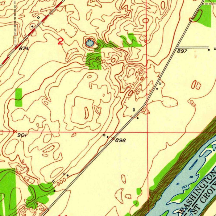
Published in 1959 using survey data from 1951, the “Stillwater Quadrangle” captures one of Minnesota’s most storied river towns at a revealing mid-century moment. Produced by the US Geological Survey at the detailed 1:24,000 scale, the map presents Stillwater and its surrounding landscape with the precision and visual restraint characteristic of federal topographic mapping. Stillwater, set along the St. Croix River, was already renowned as one of Minnesota’s oldest settlements, closely associated with lumber, river commerce, and the state’s early civic development. This map preserves the area before later waves of suburban expansion reshaped roads, neighborhoods, and land use, offering a finely grained portrait of town, river, woodland, and rural terrain as they stood in the early 1950s.
The cartographic language of the map is both practical and elegant: blue waters, green wooded or park areas, fine contour lines, and carefully differentiated symbols for roads, railways, buildings, and other infrastructure. Its topographic contours reveal the physical character of the St. Croix Valley, where slopes, bluffs, lowlands, and drainage patterns give structure to the region. Rather than presenting geography as a flat arrangement of names and boundaries, the map allows the land to rise and fall before the eye. Hills and valleys are legible, lakes and ponds stand out crisply, and the relationship between settlement and terrain becomes immediately apparent. It is a working map, but one with a quiet, highly ordered beauty.
At the heart of the sheet is Stillwater, a city whose history is inseparable from the St. Croix River. The map shows the urban fabric gathered near the river corridor, reflecting the importance of waterborne movement, industry, and commerce in the city’s development. Across the wider quadrangle, rural roads, rail lines, open lands, and scattered development speak to a landscape balanced between town and countryside. The St. Croix River and Lake St. Croix provide the dominant geographic presence, shaping movement, settlement, and scenery. Their blue forms anchor the composition, while the surrounding network of roads and contours shows how human occupation adapted to the valley’s natural form.
The US Geological Survey, founded in the late nineteenth century, became one of America’s most important institutions for systematic mapping, resource assessment, and land-use knowledge. Maps such as the “Stillwater Quadrangle” were created not merely for navigation, but for engineers, planners, scientists, foresters, civic officials, and anyone concerned with the careful management of land and water. By the 1950s, USGS topographic mapping had achieved a distinctive balance of accuracy and readability, combining field survey, standardized symbology, and disciplined design. This quadrangle belongs to that tradition: a map made for practical use, yet rich with historical meaning because it records a landscape at a specific point in the nation’s postwar transformation.
Today, the map is especially compelling as a document of change. It depicts Stillwater and its neighboring lakes, ponds, parks, wooded areas, transportation routes, and developing settlements before the full force of late twentieth-century urbanization altered the metropolitan edge of the Twin Cities region. The roads and railways trace patterns of movement; the contours preserve the enduring shape of the land; the green and blue areas mark natural features that continue to define the character of the St. Croix Valley. For collectors, historians, and admirers of Minnesota geography, the “Stillwater Quadrangle” offers more than topographic information—it is a refined historical snapshot of place, landscape, and growth along one of the Upper Midwest’s great river corridors.
Cities, towns and places on this map
- Stillwater
- St. Croix River
- Lake St. Croix
- Various lakes and ponds depicted in blue
- Parks and forested areas depicted in green
- Surrounding rural and urban developments
- Roads and railways indicated by specific lines
- Contours representing elevation changes
Historical context & cartographic details
- Name of the map: Stillwater Quadrangle
- Produced by the US Geological Survey (USGS)
- Historical topographical map at a scale of 1:24,000
- Based on survey data from 1951 and published in 1959
- The US Geological Survey has a long history of creating detailed maps for resource management and land use planning
- Stillwater is historically significant as one of the oldest towns in Minnesota and is located along the St. Croix River
- Features a clear color palette with symbols denoting topographical features, water bodies, and infrastructure
- Represents land use and geographical characteristics of the area in the early 1950s, showing how development and urbanization may have changed over time
Looking for a particular place? Review the detailed images to confirm that the town, landmark or feature you have in mind appears on the map. If you are unsure, ask our workshop to check before you order.
Detailed maps are especially rewarding at larger sizes, where names, boundaries and decorative features have more room to be appreciated. Use the close-up preview and size guide to choose the right scale for your wall.
This map looks amazing at sizes all the way up to 50in (125cm). If you are looking for a larger map, please get in touch.
The model in the listing images is holding the 16x20in (40x50cm) version of this map.
Where personalisation is available, you can add a short title or dedication, mark one meaningful place, or request one considered visual detail. See personalised map examples.
Every piece is printed to museum-grade archival standards using fade-resistant pigment inks on acid-free matte paper. Choose an unframed map print, framed map or canvas using the finish options above. Framed maps use crystal-clear optical acrylic and arrive ready to hang.
With its rich detail and strong sense of place, this map makes a considered gift for a new home, anniversary, retirement or anyone with a personal connection to the area shown. Still deciding? Explore our collection of rare old and vintage maps to discover another place, period or style.