Old Map of Lutsen, Minnesota by USGS, 1919 – Grand Marais & Lake Superior
Old Map of Lutsen, Minnesota by USGS, 1919 – Grand Marais & Lake Superior
✅ Made In USA
✅ Quick Delivery
✅ Cruelty Free
BUNDLE & SAVE
BUNDLE & SAVE
Couldn't load pickup availability
-
Ordered
- - -
Order Ready
- - -
Delivered

Old Map of Lutsen, Minnesota by USGS, 1919 – Grand Marais & Lake Superior
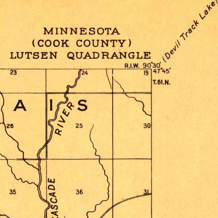
Published in 1943 from survey work first created in 1919, the US Geological Survey’s “Lutsen” map captures a remarkable stretch of Minnesota’s North Shore at a formative moment in its modern history. Centered on Lutsen and extending toward Grand Marais, Lockport, Brule Lake, and the vast inland edge of Lake Superior, the map presents the region with the disciplined clarity characteristic of early twentieth-century federal cartography. Its 1:62,500 scale allows the viewer to read both settlement and wilderness together: roads, waterways, shorelines, contours, and named places combine into a portrait of a landscape still sparsely developed, yet increasingly legible to travelers, planners, surveyors, and residents.
The United States Geological Survey, founded in 1879, became one of the defining institutions in American mapmaking, translating immense and varied terrain into standardized, practical, and scientifically grounded sheets. This Lutsen quadrangle reflects that mission with particular elegance. The cartography is functional but never austere: a measured grid aids orientation, clear labeling anchors towns and water bodies, and the familiar USGS tonal palette helps separate landform, drainage, and human infrastructure. The map’s classification as both advance and planimetric speaks to its practical purpose, emphasizing navigable geographic information while preserving the broader topographic intelligence needed to understand this rugged corner of Minnesota.
Lake Superior dominates the composition, not merely as a boundary but as the defining natural force of the map. Its cold northern shore bends past Lutsen and Grand Marais, shaping settlement patterns, transportation routes, and the very sense of scale. Inland, the terrain rises into a broken country of hills, valleys, streams, and forested uplands, rendered through contour lines and hydrographic detail. Brule Lake and the surrounding waterways hint at the interconnected lake-and-river systems that made the region important for travel, logging, fishing, and later recreation. The result is a map that balances coastal drama with the quieter complexity of the interior landscape.
Historically, this sheet records the North Shore before the full transformation brought by later road improvements, resort development, and expanding tourism. Lutsen, now closely associated with skiing, outdoor recreation, and scenic travel, appears here in a more restrained cartographic context: a place within a remote and demanding landscape rather than a destination marketed for leisure. Grand Marais, long a harbor community and gateway to the interior, provides another point of human reference along the lakeshore. Comparing this early twentieth-century geography with the present reveals shifting patterns of access, land use, population, and environmental management across one of Minnesota’s most evocative regions.
As a historical topographical document, the “Lutsen” map offers more than geographic information; it preserves a particular way of seeing the land. The grid, contours, shorelines, and settlement names form an ordered interpretation of a place where wilderness and infrastructure meet. Its restrained design rewards close study, inviting the eye to follow unnamed rivers, trace elevation changes, and imagine the routes between harbor, forest, lake, and ridge. For collectors drawn to Great Lakes history, American survey cartography, or the evolving geography of the Upper Midwest, this map stands as a finely detailed record of Minnesota’s North Shore at the intersection of exploration, measurement, and change.
Cities, towns and places on this map
- Lutsen
- Grand Marais
- Lake Superior
- Lockport
- Brule Lake
- Several unnamed rivers
- Elevation and contour features, including hills and valleys
Historical context & cartographic details
- Produced by the United States Geological Survey (USGS).
- Historical 1:62,500 topographical map of Lutsen, Minnesota and the surrounding area.
- Created in 1919 and published with a 1943 imprint.
- Classified as an advance and planimetric map.
- Uses a structured grid system for navigation and reference.
- Features prominent labeling for landmarks and water bodies.
- Employs typical USGS colors from the period, with a toned background to enhance topographical detail.
- Depicts elevations, water bodies, hills, valleys, and the broader lay of the land.
- Serves as an early 20th-century geographic record of the Lutsen area.
- Useful for comparing historical land use, road development, and population growth with the modern landscape.
Looking for a particular place? Review the detailed images to confirm that the town, landmark or feature you have in mind appears on the map. If you are unsure, ask our workshop to check before you order.
Detailed maps are especially rewarding at larger sizes, where names, boundaries and decorative features have more room to be appreciated. Use the close-up preview and size guide to choose the right scale for your wall.
This map looks amazing at sizes all the way up to 50in (125cm). If you are looking for a larger map, please get in touch.
The model in the listing images is holding the 16x20in (40x50cm) version of this map.
Where personalisation is available, you can add a short title or dedication, mark one meaningful place, or request one considered visual detail. See personalised map examples.
Every piece is printed to museum-grade archival standards using fade-resistant pigment inks on acid-free matte paper. Choose an unframed map print, framed map or canvas using the finish options above. Framed maps use crystal-clear optical acrylic and arrive ready to hang.
With its rich detail and strong sense of place, this map makes a considered gift for a new home, anniversary, retirement or anyone with a personal connection to the area shown. Still deciding? Explore our collection of rare old and vintage maps to discover another place, period or style.