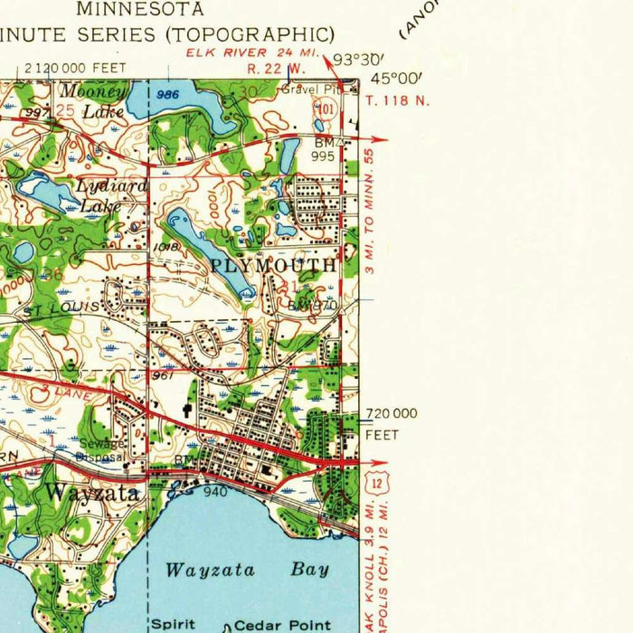
Old Map of Lake Minnetonka, Minnesota by USGS, 1958 – Excelsior, Wayzata & Crystal Bay
Old Map of Lake Minnetonka, Minnesota by USGS, 1958 – Excelsior, Wayzata & Crystal Bay
✅ Made In USA
✅ Quick Delivery
✅ Cruelty Free
BUNDLE & SAVE
BUNDLE & SAVE
Couldn't load pickup availability
-
Ordered
- - -
Order Ready
- - -
Delivered

Old Map of Lake Minnetonka, Minnesota by USGS, 1958 – Excelsior, Wayzata & Crystal Bay
Titled “Lake Minnetonka,” this 1:62,500 topographical map was published in 1959 using survey data from 1958, capturing one of Minnesota’s most storied lake districts at a fascinating mid-century moment. Centered on Lake Minnetonka and the communities of Excelsior, Wayzata, Crystal Bay, Minnetonka Beach, and Spring Park, it presents a landscape poised between resort-era charm and accelerating suburban development. The map’s intricate rendering of bays, peninsulas, roads, rail lines, and wooded tracts evokes a region shaped by water, recreation, and proximity to Minneapolis. Its title may be modest, but the geography it describes is richly varied: a many-armed lake system surrounded by settlements, shore roads, small ponds, and gently rolling terrain.
The map was created by the U.S. Geological Survey, the nation’s preeminent scientific mapping agency and one of the most influential cartographic institutions in American history. Since the late nineteenth century, the USGS has supplied the geographic framework used for land management, infrastructure planning, environmental study, and navigation across the United States. Its topographic maps are admired for their precision, clarity, and disciplined visual language: contour lines to express elevation, blue hydrography for lakes and streams, black and red linework for roads and built features, and green shading for wooded areas. In this Lake Minnetonka sheet, that systematic style transforms a complex lakeside region into an elegant, readable portrait of land and water.
Lake Minnetonka itself dominates the composition, its irregular shoreline unfurling into named reaches and intimate coves. Gray’s Bay, Lafayette Bay, the North Arm, and the South Arm reveal the lake not as a single simple body of water, but as a branching aquatic landscape of passages, promontories, and sheltered basins. The Port of Excelsior appears along the southern shore, recalling the town’s long association with lake travel, leisure, and summer visitors. Wayzata anchors the northeastern side, while Minnetonka Beach and Spring Park occupy narrow corridors of land between water and road. Around them lie smaller unnamed lakes and ponds, reinforcing the region’s glacial character and its deep connection to water.
Historically, the Lake Minnetonka area developed from a rural and resort landscape into one of the Twin Cities region’s most desirable suburban environments. By the time this map was surveyed in 1958, highways and roads were increasingly structuring movement around the lake, while older railroad lines still marked the transportation networks that had helped bring visitors and residents to its shores. Excelsior and Wayzata, once celebrated as lake resort destinations, were becoming year-round communities within a growing metropolitan orbit. The map quietly records this transition: shorelines show settlement, inland areas retain wooded and open character, and transportation routes trace the pressures and possibilities of postwar growth.
The topographic character of the sheet gives the surrounding landscape a subtle but important dimensionality. Contour lines describe low ridges, depressions, and gentle rises around the lake, helping the viewer understand how roads, settlements, and shorelines relate to the terrain. Dense vegetative areas are carefully distinguished, emphasizing the natural beauty that long defined the Lake Minnetonka region and continues to shape its appeal. The contrast between the finely articulated water bodies and the patterned land surface makes the map both scientifically useful and visually compelling. It is a measured, mid-century portrait of a celebrated Minnesota lake district, balancing exacting survey work with the quiet elegance of classic USGS cartography.
Cities, towns and places on this map
- Lake Minnetonka
- Excelsior
- Wayzata
- Crystal Bay
- Minnetonka Beach
- Spring Park
- Gray's Bay
- Lafayette Bay
- Port of Excelsior
- The North Arm
- The South Arm
- Various unnamed lakes and ponds
- Railroad lines
- Highways and roads
- Nearby parks and forested areas
Historical context & cartographic details
- Historical 1:62,500 topographical map of the Lake Minnetonka region in Minnesota.
- Produced using survey data from 1958 and published with a 1959 imprint.
- Created by the U.S. Geological Survey, a major American mapping and geological data organization.
- The USGS has a long history of producing accurate geographic data for land management, environmental protection, and scientific research.
- Uses a detailed USGS topographic style, including contour lines, water bodies, roads, and vegetation.
- Shows elevations and depressions in the landscape, making it useful for navigation and outdoor activities.
- Reflects a period when the Lake Minnetonka area was shifting from rural and natural landscapes toward more urbanized development.
- Careful delineation of water bodies and dense vegetative areas highlights the natural beauty and geographic diversity of the region.
Looking for a particular place? Review the detailed images to confirm that the town, landmark or feature you have in mind appears on the map. If you are unsure, ask our workshop to check before you order.
Detailed maps are especially rewarding at larger sizes, where names, boundaries and decorative features have more room to be appreciated. Use the close-up preview and size guide to choose the right scale for your wall.
This map looks amazing at sizes all the way up to 50in (125cm). If you are looking for a larger map, please get in touch.
The model in the listing images is holding the 16x20in (40x50cm) version of this map.
Where personalisation is available, you can add a short title or dedication, mark one meaningful place, or request one considered visual detail. See personalised map examples.
Every piece is printed to museum-grade archival standards using fade-resistant pigment inks on acid-free matte paper. Choose an unframed map print, framed map or canvas using the finish options above. Framed maps use crystal-clear optical acrylic and arrive ready to hang.
With its rich detail and strong sense of place, this map makes a considered gift for a new home, anniversary, retirement or anyone with a personal connection to the area shown. Still deciding? Explore our collection of rare old and vintage maps to discover another place, period or style.