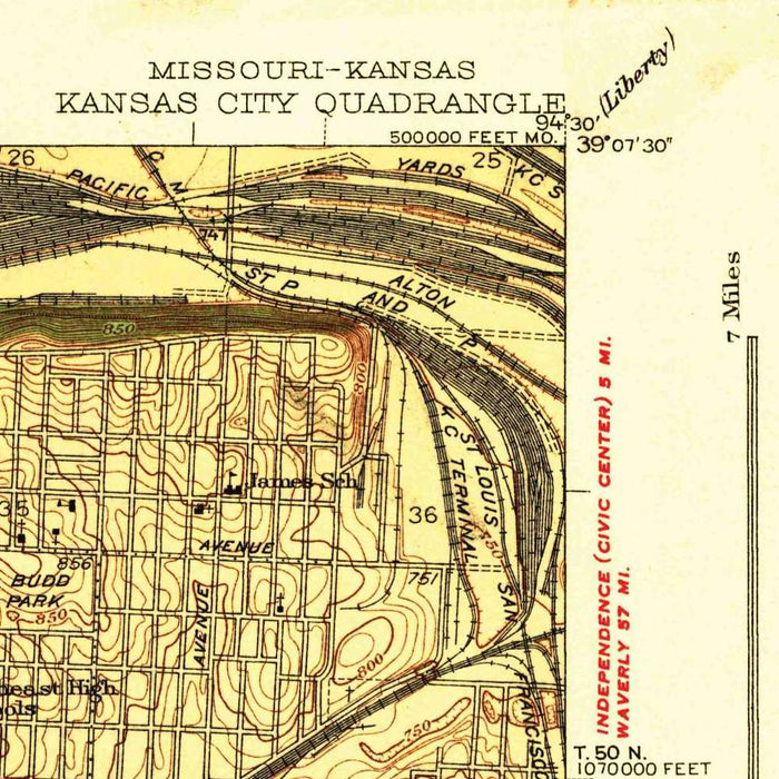
Old Map of Kansas City, Missouri by USGS, 1940 – Missouri River, Kansas River & Westport
Old Map of Kansas City, Missouri by USGS, 1940 – Missouri River, Kansas River & Westport
✅ Made In USA
✅ Quick Delivery
✅ Cruelty Free
BUNDLE & SAVE
BUNDLE & SAVE
Couldn't load pickup availability
-
Ordered
- - -
Order Ready
- - -
Delivered

Old Map of Kansas City, Missouri by USGS, 1940 – Missouri River, Kansas River & Westport
Published in 1940 by the United States Geological Survey, “Kansas City” presents a finely measured portrait of one of the Midwest’s great metropolitan crossroads. At a scale of 1:31,680, the map captures Kansas City, Missouri, and its surrounding districts with the disciplined clarity for which the USGS became renowned. This was a city already shaped by railroads, stockyards, manufacturing, river commerce, and music, yet still poised before the postwar transformation that would redraw its suburbs and highways. The Missouri and Kansas rivers anchor the composition, while the gridded city spreads outward from the bluffs and bottoms. As a historical document, it fixes Kansas City at a particularly revealing moment between nineteenth-century industrial geography and twentieth-century metropolitan expansion.
The map’s topographic language is both scientific and elegant: contour lines step across the sheet in measured intervals, revealing the hills, valleys, and river terraces beneath the urban fabric. Roads appear in varying strengths, distinguishing major routes from local streets, while rail lines thread through the industrial lowlands with unmistakable prominence. The color scheme separates dense urban settlement from open ground, parkland, and undeveloped terrain, allowing the viewer to read both the built city and its natural setting at a glance. Green areas identify parks and public lands, while lighter tones mark the expanding street grid. The result is a visually rich map in which civic order, industrial infrastructure, and Midwestern topography are held in careful balance.
Kansas City’s physical drama comes from its rivers, and this map gives them their due. The Missouri River curves along the northern edge of the urban core, while the Kansas River joins from the west, forming the low-lying industrial district known as the West Bottoms. These bottomlands, prone to flooding yet invaluable for rail access and commerce, contrast sharply with the higher residential and commercial districts climbing the bluffs to the south and east. The Blue River and its tributary valleys add further texture, cutting through the southeastern landscape toward Swope Park and beyond. Through contour and drainage detail, the map reveals how the city’s growth was constrained, encouraged, and continually negotiated by water and relief.
Many of Kansas City’s defining places can be traced across the map’s dense urban pattern. Union Station, a monumental gateway to the city’s rail age, sits within a web of tracks that speaks to Kansas City’s role as a national transportation hub. Westport appears as an older settlement absorbed into the expanding city, carrying memories of frontier trails and nineteenth-century commerce. Streets such as Troost Avenue, Vine Street, 39th Street, and 75th Street help orient the viewer within neighborhoods that were already socially, culturally, and economically distinct. The map quietly evokes the city’s jazz-era vitality, its manufacturing base, and the layered geography of residential districts, commercial corridors, parks, and public institutions.
Seen today, this 1940 USGS map is especially compelling for what it precedes. It records Kansas City before the full force of postwar suburbanization, interstate highway construction, and later metropolitan decentralization altered the region’s form. Areas that would become more intensively developed, including communities on the Kansas side such as Overland Park, are shown in a comparatively open or transitional state. Swope Park and other green spaces stand out as deliberate civic landscapes amid spreading neighborhoods and transportation corridors. The map is therefore more than a technical survey: it is a snapshot of urban possibility, showing a city still closely tied to rivers, railroads, street grids, and the contours of the land beneath it.
Cities, towns and places on this map
- Kansas City, Missouri
- Missouri River
- Kansas River
- The West Bottoms
- Union Station
- Westport
- Vine Street
- Troost Avenue
- 39th Street
- 75th Street
- Overland Park
- Blue River
- Swope Park
- Kansas City International Airport (airport labeled area)
- Various parks and public lands
- Residential neighborhoods and mixed-use districts
- Major roadways and railroads, including Interstate routes
Historical context & cartographic details
- Produced by the US Geological Survey, this historical 1:31,680 topographical map shows Kansas City, Missouri, and the surrounding area.
- Date of the map: 1940.
- Published by the US Geological Survey, a key United States agency known for accurate mapping, surveying, and topographical methods.
- The map illustrates Kansas City as a significant urban area known for its cultural and economic contributions, including jazz heritage and manufacturing.
- Detailed contour lines represent elevation changes across the landscape.
- Road grids are shown with varying thicknesses to distinguish routes and urban structure.
- The color scheme categorizes different land uses and topographic features.
- Terrain variations are shown through contour lines and shading, revealing hilly areas adjacent to river valleys.
- The map captures Kansas City before significant later urban development and demographic change.
- It serves as a historical reference for understanding urban growth patterns and land use changes.
- Color differentiates urban and natural areas, with green used for parkland and undeveloped areas.
Looking for a particular place? Review the detailed images to confirm that the town, landmark or feature you have in mind appears on the map. If you are unsure, ask our workshop to check before you order.
Detailed maps are especially rewarding at larger sizes, where names, boundaries and decorative features have more room to be appreciated. Use the close-up preview and size guide to choose the right scale for your wall.
This map looks amazing at sizes all the way up to 50in (125cm). If you are looking for a larger map, please get in touch.
The model in the listing images is holding the 16x20in (40x50cm) version of this map.
Where personalisation is available, you can add a short title or dedication, mark one meaningful place, or request one considered visual detail. See personalised map examples.
Every piece is printed to museum-grade archival standards using fade-resistant pigment inks on acid-free matte paper. Choose an unframed map print, framed map or canvas using the finish options above. Framed maps use crystal-clear optical acrylic and arrive ready to hang.
With its rich detail and strong sense of place, this map makes a considered gift for a new home, anniversary, retirement or anyone with a personal connection to the area shown. Still deciding? Explore our collection of rare old and vintage maps to discover another place, period or style.